Thursday morning, in a rush to beat the incoming storm, I threw all my gear in the Subaru and managed to escape Leadville. The roads were pretty dicey all the way to Minturn, but once I hit I-70 conditions weren't too bad-- just one localized blizzard outside of Rifle. It figures, just a week after I had swapped the snow tires off both our cars, the biggest storm of the season strikes. While I was away at the Grand Canyon, my wife got to deal with the 20+ inches of snow that fell on Leadville! So much for my dreams of the local trails melting out soon! Having camped in Fruita on spring break just two weeks ago, it felt very strange to drive through it again and see the mesas blanketed with snow. I stopped at The Hot Tomato, grabbed some pizza, and continued on to Moab, following beautiful 128 along the Colorado River.
Just outside of Moab, I hopped out of the car, stretched some more, and went on another test run to visit Morning Glory Arch. It was cloudy and chilly and the skies spat rain and hail on my return. I arrived back at the car soaked and numb, but no worse for wear. My knee was a little grumpy, but fine. I ate dinner, snagged a campsite in Sand Flats, enjoyed a beautiful sunset, and slept in the back of the Subaru. It drizzled all night. The pitter-patter on the roof of the car seemed out of place in the desert. I awoke to more clouds and drizzle. I was just below the snow line.
 |
| The sun sets over Moab. |
 |
| The La Sals in the distance. |
I met Alex, Erin, and the kids for a quick breakfast in Moab before hitting the road again. I drove through another snow storm in Blanding before driving through Monument Valley in the haunting clouds. It was still surprisingly chilly. Snow laced the sagebrush and accented the red slick rock. As I got closer to the Grand Canyon, a few spots of sunshine began to break through the clouds. I arrived shortly after noon and went on another short, easy test jog along the paved Rim Trail, weaving through all the tourists. The canyon was as majestic as ever. My knee seemed to be cooperating. I met Alex at our campsite in Mather Campground. We spent a leisurely afternoon catching up and making final preparations for our run. After a quick dinner at the lodge, and a beer or two, I set my alarm and curled up in my sleeping bag, breakfast at my side.
I woke up at 4 am, ate my breakast (two pieces of banana bread, a smoothie, and an espresso), and crawled out of my bag around 4:30 am or so. After fumbling around with our gear, and some final stretching on my part, we drove the short distance to Yaki Point, parked at the nearby picnic area, and headed out. It was about 5:30 am and just getting light. The idea was to leave as early as we could without needing headlamps. I wanted to enjoy the views as we descended the South Kaibab Trail into the canyon.


What followed was an amazing, amazing day of running. I'll spare you the blow-by-blow details, and try to summarize my experience as best I can.
First, the plan. It was quite simple, really. South Kaibab to North Kaibab and back. Roughly 42 miles and almost 11,000 feet of vertical. (We parked about a half a mile away from the trail head, so it ended up being about 43 miles total.) Many runners we met along the way planned to ascend back up Bright Angel Trail, which is a mile or two longer, but has water at Indian Garden. Instead, we simply retraced our steps taking the shorter, steeper, drier South Kaibab Trail. (Which is considered the standard route, I'd say.) We each had enough water capacity to survive the 2-3 hour climb.
We heard reports that the water was actually turned on at the North Rim, which would make our lives much easier. It meant we wouldn't have to carry as much from Cottonwood Campground up to the North Rim.
Alex has run the R2R2R route 5 or 6 times. (So many that he's lost count!) I attempted it with him in '13, but I had to turn back due to a bad case of the stomach flu. Now, two years later, I was back for some redemption. Alex is training for Wasatch-- a September race-- so his training is just getting started. (In contrast to, say, last year when he was training for Bighorn-- a June race.) And, while I'm almost certainly in better shape than I've ever been in April, I was nursing a gimpy knee and I really wanted to take the time to soak in the scenery and enjoy the day. In other words, this was not a FKT attempt (far from it!) nor were we chasing PR's. The plan was to take things easy, don't rush, take lots of pictures, and have fun.
And that we did!
It was a truly spectacular day. Perfect weather. The recent precipitation seemed to have washed the dust out of the air, making for very clear skies. It was hot at the bottom of the canyon in the afternoon, but not too hot. I'm sure it can be far, far worse. Within, I'd say, 30 minutes we had peeled off our hats, gloves, and long-sleeved shirts. Though frigid at the rim at the start, it warmed up quickly on the way down. If you're willing to suffer for a bit, you can skimp on extra layers if you'd like.
We took it super easy on the steep downhills, chatting away. Alex has a degree in geology and is a fantastic companion to have in the Grand Canyon, as you might imagine.
We refilled at Bright Angel Campground, snacked, used the facilities, and headed off through the narrows gently up to Cottonwood Campground. The whole R2R2R route can be roughly broken up into: 7 miles down, 7 miles flat, 7 miles up, turn around, repeat. The flattish section from BAC to CCG is very runnable (in both directions). Once we emerged from the narrows, it was all new terrain to me. I was forced to turn around and stagger back to the South Rim shortly after the first set of bridges in '13.


To my utter amazement, my knee was holding up just fine. It somehow survived the initial 5,000 ft descent to the river-- not exactly how you want to start a run when you're suffering from a knee injury! My confidence was building as the miles clicked by. It looked like the day wouldn't turn into the limping disaster that I had feared. We were in shadow almost all the way to Cottonwood Campground, where we stopped and took our second break. A short while later we stopped at the Pump House, where the water was also turned on. Then began our ascent to the North Rim. Up until this point, we'd seen backpacker activity around Phantom Ranch, and Cottonwood Campground, but only met a few folks out on the trail. The trail population would increase as we neared the turnaround.
The canyon was surprisingly lush. The light green of new leaves popped out on the trees and cacti. Flowers were everywhere. Some kinds I recognized, others were new to me. All beautiful. The North Rim of the canyon is much wetter than the South Rim, and in places water gushed from steep cliff faces. The trail was dramatically cut from the canyon walls. An engineering feat which was at times vertigo-inducing. As we climbed, we started crossing paths with other backpackers (who had started from the canyon bottom) and more and more runners. I'd say there were about 3-5 folks attempting the R2R2R in front of us, and maybe another dozen behind us. I was actually expecting more given the timing of our run-- the peak season for this kind of crazy adventure.


The North Rim is about 1,000 ft higher than the South Rim and felt very different. Chillier, certainly. Snow still lingered from the recent storm. Aspens made their appearance. By the time we had finished our snack I was almost shivering in my shorts and t-shirt. It was time to get moving again and warm up.
I stopped and took 100's of photos on the return trip. The scenery seemed to demand it! I was high on endorphins and loving life! I kept thinking to myself, "This, dammit, is why I run! This is why I slog down the Boulevard everyday during winter!" Believe it or not, I was a little skeptical that the run would be really worth the 9+ hour drive to and from the Grand Canyon. (That's a lot of time in the car. More time than I spent running.) But, yes. Yes, it was! The R2R2R should be on every runner's bucket list. It's totally worth it.


 |
| Roaring Springs |


 |
| A burst pipe. All water on the South Rim is pumped from the North Rim. |

 |
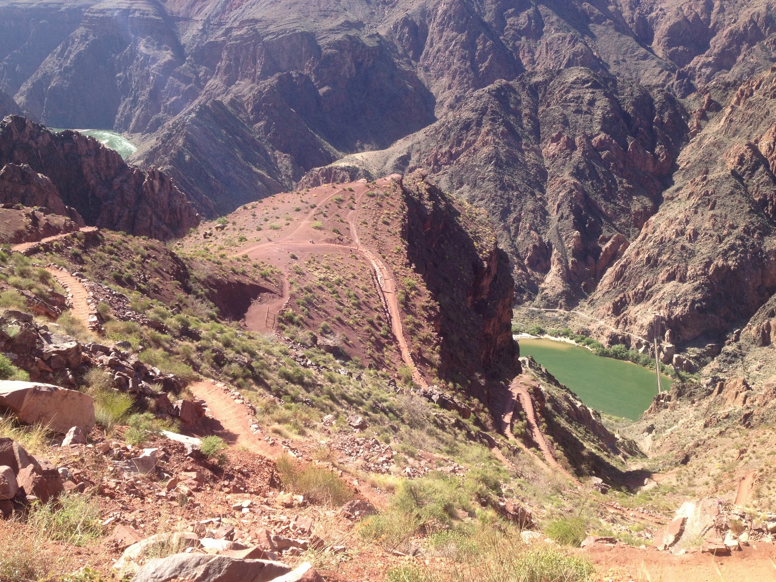
| Approaching Phantom Ranch |
At Phantom Ranch, I bought a few Snickers bars to fill my stomach for the final climb ahead. (It's a good idea to carry some cash with you for just this reason. The R2R2R is actually quite civilized.) I also slurped down another Clif sweet potato pouch. I'd been drinking Tailwind all day and it was getting the job done, but it was also nice to eat some savory food every once in a while. So, each leg I'd get about 500 calories from Tailwind, 100-200 calories from Clif pouches, and maybe 100 calories from a GU. I'd try to polish off 20 oz of Tailwind every 45 minutes and drink maybe an extra 10 oz of water at the various water stops. For the final climb up to the South Rim, I brought two 500 ml soft flasks to carry extra water, which I filled at Bright Angel Campground.
I managed to grunt up the final climb without digging myself into too deep of a hole. I must confess that I did start slacking off on nutrition a bit as I neared the finish, and I probably suffered more than I had to. There were a few sections that I hiked that I probably should've jogged, but at least I never completely imploded. By the time we were climbing, the sun was low enough that there were actually some nice stretches of shade on the way up. A breeze also kicked in the higher up we got. So, the heat actually wasn't too brutal. I continued to shake my head in amazement at the scenery and stopped to take plenty of pictures. We met Alex's wife and kids just past Ooh Aah! Point, maybe a mile from the South Kaibab Trail Head. Despite tired legs, all the dust and dirt, and (in my case, at least) being encrusted with salt, we still had smiles on our faces!


 |
| The Hardrock beard is coming along nicely! A little more gray this time, though... |


What a fantastic, fantastic run! I'm so glad that I carved out the time and went back this year to finally complete it. Without a doubt, it was a great training run for Hardrock and the highlight of my spring.
Some numbers.
As you might imagine, GPS doesn't work so well in the canyon. Mine was flaking out in the narrows and for most of the climb up the north side. So, all you can really do is go by time when you're checking your watch. Your mileage and your pace are almost always wrong.
Now, that's all moving time. As I do on all my long runs, I stopped my watch whenever I stopped to refill water, snack, visit the bathroom, shop, take pictures, text my wife, stretch, etc. My total elapsed time was 12:27:17 (including to and from the car). So, obviously, that's a lot of stopped time. But, I have no regrets! I can't imagine racing through all that scenery, always on the clock-- at least on my first trip. My pace was very easy throughout. I doubt my HR ever went above MAF.
Some numbers.
As you might imagine, GPS doesn't work so well in the canyon. Mine was flaking out in the narrows and for most of the climb up the north side. So, all you can really do is go by time when you're checking your watch. Your mileage and your pace are almost always wrong.
To SKTH 0:06:46
To BAC 1:16:07
To CWC 1:32:30
To NKTH 2:06:03
To CWC 1:17:18
To BAC 1:13:02
To SKTH 2:32:37
To CAR 0:11:43
TOTAL 10:16:08
R2R2R 09:58:21Now, that's all moving time. As I do on all my long runs, I stopped my watch whenever I stopped to refill water, snack, visit the bathroom, shop, take pictures, text my wife, stretch, etc. My total elapsed time was 12:27:17 (including to and from the car). So, obviously, that's a lot of stopped time. But, I have no regrets! I can't imagine racing through all that scenery, always on the clock-- at least on my first trip. My pace was very easy throughout. I doubt my HR ever went above MAF.
 |
| I wore Hoka Cliftons. They worked really well, I think. Tailwind has a frickin' ton of salt! |