I thought it'd be a good idea to log at least one 20 mile run before my marathon next month-- even though the plan (such as it is) is to basically run the marathon on the fumes of my training from the summer. For me, the Bay State Marathon is more of an experiment in how my Leadville training translates into a flat, sea level road marathon-- not what is the ideal way to train for a flat, sea level road marathon when you live way up in the mountains.
For a while now I had considered stitching together several of my regular short midweek runs into a longer route that would take me around Iowa Gulch-- a sort of farewell tour before the snow sets in. At first I had planned to start/finish the run from my house, but that plan was more logistically difficult than simply driving to the halfway mark so that I could stash extra food and water in my car. The one drawback of doing long runs on the east side of town is that, due to all the mining activity, I don't really trust any of the water sources. Thus, I tend to run my long runs on the west side of the valley (near the Colorado Trail) where I can stop and restock on water whenever I cross a stream.
This run would also be a test to see how my IT band reacted to running for 4+ hours. It has been holding up well on my 5-6 mile runs, and it's even survived a 12 mile run, but I had yet to challenge it with anything longer than 2 hours. Occasionally I can feel it ache a bit on gentle uphill sections, but it fades away and never alters my stride. It's strange: my previous IT issues have always manifested themselves on downhills-- not uphills. I wonder what's different this time?
So, the weatherman lied. Saturday was supposed to be the cloudy day and Sunday was supposed to be clear. Instead it was the reverse. There were uncharacteristic dark, gray rain clouds hovering over the Mosquitoes when I started out at 10am. If there is any overcast in Leadville, it generally doesn't arrive until well past noon. To wake up to clouds is rare. Since I'm a chicken when it comes to dark clouds above tree line, I knew this would probably put a damper on my plans to summit Mt. Sherman. But, I'd see how far I'd make it before I talked myself into retreating back down into the valley.
I drove 5 minutes up California Gulch and parked my car at the pull off at the top of Printer Boy. (Where the first major aid station is on the Silver Rush 50 course.) I decided to tackle the high road up the gulch first (2B).
 |
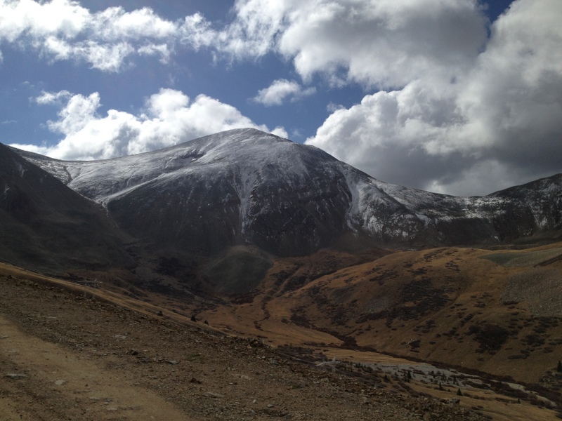
| Mt Sherman is the snowy ridge in the distance. |
 |
| Mt Sheridan. The trail climbs up the notch on the left. |
 |
| A view of West Sheridan across the gulch. |
 |
| Nearing the end of the road and the Mt Sherman trailhead. |
I climbed up the road fairly well, though I was actively trying to keep my HR low. The road gains about 1,000 ft in 3.5 miles. It was chilly and windy on the way up. I knew it'd only get worse the higher I got. (Dammit, I should have run this yesterday!) At the junction with the trail to the summit, I took stock of things and decided, what the hell, I'd climb up to the saddle and see how things looked from there. I felt surprisingly good on the way up the trail, running a few of the flatter sections, and power hiking through the steep fields of scree. My mind drifted towards potential Hardrock training next year...
 |
| At the top of the pass, looking towards Mt. Sheridan. |
 |
| Looking north towards the summit of Mt. Sherman. |
 |
| Looking east at some unfriendly clouds. |
Once I crested the pass, I could see a few different groups of climbers descending off the mountain to the east. The sky really hadn't cleared up much and a patch of dark clouds was blowing in from the northwest. It was quite chilly even in the rare patch of sun that I was standing in. And I was running a little low on water. After considering the pros and cons I finally overcame my strong peak bagging instinct and turned around and re-traced my steps back down into the gulch. I had climbed up to 13,200 ft and I was exactly 5 miles from the car. The trip back went quickly, and I had a few opportunities to practice my scree-skiing technique on the way down. Once back at the trail head I took the rougher, low road (2) back down the valley, past the remnants of the Black Cloud mine, and back up Printer Boy hill to my waiting car. There I restocked on water and fuel and headed off down the Elk Run trail.
 |
| Don't shoot! I'm not an elk! |
The next ~10 miles would all be on a dense network of twisting trails built and maintained by
the local bike club. They're only a mile from my house and they've become my favorite place to run during the week. The trails are super scenic, weaving in and out of sage brush, pines, and groves of aspens, with a fair amount of elevation gain, but nothing too steep. They loop and weave so much that it's a little hard to build up any speed, but that's a very minor complaint.
 |
| From Elk Run over to Upper Deck. |
 |
| Down Wedgie. |
 |
| Down Cold Feet. |
 |
| Gel was losing its appeal, so I decided to eat elk instead. |
 |
| Gold Digger with a view of Mt. Elbert. |
 |
| Most of the aspen leaves have fallen by now, but I found one grove with its leaves still intact. |
 |
| The sage hill on Wheeler's Way. This is the first section of trail to melt out in the spring. |
 |
| A skull marks the trail on Wheeler's Way. |
 |
| Back up Old Chub to the intersection of Elk Run and Boulders. |
 |
| The ramshackle bridge across the stream on Boulders. This was the low point of my run, it's all uphill from here. |
 |
| The boulders which give Boulders its name (I assume). |
 |
| A vertigo-inducing mine shaft that plunges 100 ft into the darkness. |
 |
| The beavers have been busy and this river crossing is now knee deep! |
 |
| A view back up Iowa Gulch towards Mt. Sherman. |
The tangled, circuitous route I took never retraced its steps. I eventually ended up on the Boulders Trail and headed slowly back up the valley to my car, eventually connecting with a rough, dirt road (6A) after 8 miles of beautiful single track. I was having a great time, though my energy levels were very low. I couldn't quite put my finger on why I was slowing down so much... In retrospect, I was probably a little dehydrated. I'm not sure that completely explains it, though. My stomach felt fine, but my legs were a bit tired and I just felt generally fatigued. Ah, well. Just because you run a 100 miler doesn't mean 20.5 miles with 4,400 ft of vertical suddenly becomes easy. Looking at my training log afterwards, I ran my last 22-miler (which had equivalent elevation gain) at almost exactly the same pace. I remember feeling pretty tired on that run too.
Despite the initially sketchy weather and my eventual exhaustion, I had a great time out on the local trails. (And no ITBS despite 4+ hours of running!) It's amazing that this kind of stuff is right out my front door. It's good to be reminded of that. Thanks to my wife for watching the kids and letting me indulge in what will probably be my last 20+ mile training run of 2012!
 |
| The Tour Du Iowa Gulch. It would be easy to tack on another ~3 miles and 2,000 ft of vertical by summiting Mt. Sherman and running the upper Boulders Trail up Long and Derry Hill... |
 |
| Not much flat. |


man, that's gorgeous. I don't know how much of it would qualify as "race-specific" baystate training, but seriously, who cares.
ReplyDeleteYeah, it was definitely not race-specific training! Quite the opposite. I think I had gained the total elevation for the marathon (300 ft, right?) in the first 1.5 miles of the run. I am trying to run faster/flatter/paved routes during the week as practice, though. I'm going to attempt a faster, paved ~10 miler this weekend and see if I can sustain <9:00 min/miles for that distance.
ReplyDeleteGreat job this weekend on your half marathon!