Just a quick update on the current conditions around Leadville for those curious about such things.
Spring has been slow-coming this year and I've had to be fairly creative trying to find routes for my long runs. I've been forced to stay on dirt roads, south-facing slopes, or exposed, sage brush-lined trails.
On Saturday I parked at the South Elbert Trailhead and was able to run the Colorado Trail all the way up to Lily Ponds-- and a little bit past it-- before the drifts got too frequent. That was a pleasant surprise. I wasn't sure if I'd have to run the 4WD road up or not. From there, it was all clear heading south on the Colorado Trail around Twin Lakes all the way to Interlaken. I've heard it's clear at least all the way to the intersection with the trail over Hope Pass. By next weekend I'm fairly confident you could run all the way around Twin Lakes without encountering significant snow.
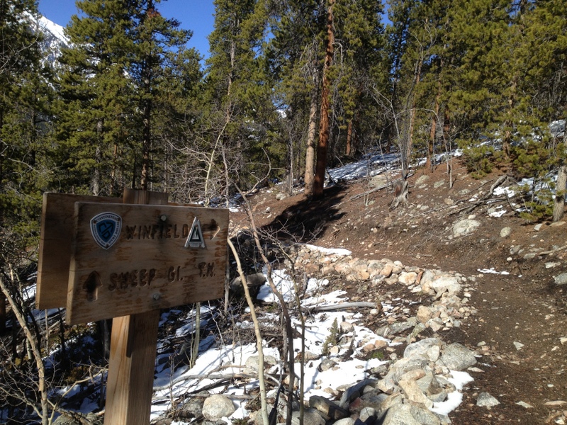
The week prior, I ran from the Colorado Trail intersection all the way up Clear Creek Road to Winfield, taking the new section of the CDT for the final few miles. All runnable-- except for a few huge drifts in the trees just before Winfield. I'm sure it's melted out even more since then.
Closer to Leadville, the single track around town is still pretty muddy/messy and there are frequent drifts to post-hole through. I've heard Turquoise Lake is still pretty well snowed in, though I haven't tried running there yet. I've heard folks are running up Halfmoon Road, which is clear. I haven't bothered trying the trails above the Fish Hatchery yet or up the Powerlines. It's all still pretty snowy. The Mineral Belt has been plowed, so if you want some fast on-pavement running, there's that for a 12.5 mile option.
I've got the Sage Burner 50K this weekend, which I'm very excited about. The weather looks to be in the 70s and sunny in Gunnison. Sweet! Hopefully by the following weekend there will be more options to explore around town... I'd guess that trails are about 6-8 weeks "behind schedule" when compared to last year.
I have a feeling that Lifetime will probably be looking for volunteers to help shovel out sections of the Marathon and Silver Rush courses this year! The snow will stick around for a long time near 12,000 ft-- especially in the willows near Ball Mtn and the top of Iowa Gulch.
 |
| 21 miles from the South Elbert Trailhead. All clear. |
 |
| 21 miles to Winfield and back. Should be all clear by now. |
 |
| Clear Creek Road on 5/11 |
 |
| Climbing up the south side of Hope Pass. |
 |
| The intersection with the new CDT section to Winfield. |
 |
| Most of the trail is probably all melted by now. |
 |
| The biggest drifts were within the last 0.3 miles before Winfield. |
 |
| The jeep road down into Winfield. |
 |
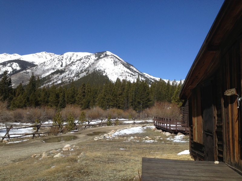
| Ah, Winfield. My first time back since the 100. |
 |
| Back on Clear Creek Road with Hope Pass in the distance. |
 |
| Big horn sheep! |


Thanks Andy. I was trying to figure out how to email you the other day and ask about the snow up there. GMTA!
ReplyDeleteAndy
Thanks for this info. I have been in town less than a week and this helps me with figuring out the lay of the land. Hope to see you out there at some point!
ReplyDeleteOnly too happy to help! I'm glad that some folks found the info useful. I think the next two weeks will open up many more options... If you have any specific questions, feel free to ask.
ReplyDeleteHi Andy - we're on our way up today for the holiday weekend and were thinking about hiking/running/snowshoeing what we could of Hope Pass - in our rose colored world we thought we might be able to do a double Hope Pass with the right gear - is that just silly? Regardless we'd like to get in a 25 mile run/hike/whatever on parts of the course - do you have any suggestions? We're at Mayqueen...Any info is appreciated.
ReplyDeleteHi Sandra,
ReplyDeleteYeah, it's going to be tough to get 25 contiguous miles in on the LT100 course this weekend. During my runs this week (which weren't on the course, granted), I've hit significant snow around ~10,800 ft on the local trails. Of course, it depends exactly where you run... south-facing slopes with minimal tree cover are your best bet. (And that's where I was running, so ~10,800 ft is the best it gets.)
Here's my best guess as to the current conditions on the course:
Start to Turquoise Lake dam: Clear.
Dam to May Queen: Not sure, probably still snow drifts in places. Snow piles up over the winter as the wind blows it across the lake.
MQ to Fish: the Colorado Trail ni this section is almost certainly still snowed in. Hagerman Pass Road is probably clear, but I bet you'll hit significant snow drifts near the top of Powerlines.
Powerlines to Fish: lower (south-facing) Powerlines is clear, but there will be drifts up high.
Fish to Pipeline: Clear (but not exciting).
Pipeline to CT: Probably clear until you hit single track.
CT to Twin: Probably too snowy until you hit the south-facing slopes down into Twin (near Lily Pond).
Twin to Hope: Probably clear until you start climbing up Hope. Snowshoes will quickly become required.
Hope to Winfield: The south-facing slopes will be better, but it'll still be snowed in above ~11,000 ft, I'd guess.
I mean, there's still enough snow on Hope that I'd be concerned about "wet slide" avalanches. Go early, if you're going to go. I'm sure it's doable.
The weather looks to be great this weekend, I'm sure you'll find some awesome runs. You may just have to string together several shorter out-and-back runs.
Enjoy!
Oh, and since you're camping at Mayqueen, I should add that I've heard that there's no running, potable water at the campgrounds yet. The lines are still frozen, I guess. That should give you a clue as to how long winter has lingered here this year! :)
ReplyDeletethank you so much for the stats and ideas (and the thing about the water at Mayqueen)I think we'll string together a kind of LT run and kind of not - either way we'll be at 10k feet regardless!!
ReplyDeleteI just got some new trail beta from my neighbor, Greg: the trail around Turquoise Lake is runnable. You may have to dodge a few snow drifts at either end, but it's good. (By the way, the lake is at the lowest level it's ever been since they built the dam.) Also, he ran up the south side of Powerlines this morning. He had to get a little creative near the top (and post holed a bit), but he made it!
ReplyDeleteHi Andy,
ReplyDeleteStumbled across your blog while Googling Sage Burner. How did the race go for you? I had a tough time, got a bit (lot!) dehydrated, and shuffled the last couple hours. But it was a gorgeous day and I enjoyed the course (even if it was hard).
I was heading up towards Breckenridge on Monday to do some long, vertical miles in preps for Silver Rush. Do you think most of the trails that you just wrote about would be more accessible by then? I'm not familiar with the area nor the trails so would prefer that I'm not lost due to wandering off the beaten path.
Thanks bunches! Hope you had a great day at SB!
Hi Jill,
ReplyDeleteUgh, I had a very tough race at Sage Burner. I got severely dehydrated and had to basically walk it in. I'm pretty frustrated with myself for making such a basic mistake. Oh, well. I'll write up all the gory details in a new blog post at some point, once I get some free time.
This weekend, on Saturday, there's a half marathon in Leadville which goes around Turquoise Lake. I'll be running that. It's fun. There's also a 5K at the Fish Hatchery on Sunday. Also fun, but I usually skip that for a long run. I'll probably try the section of the Colorado Trail from North Elbert TH to South Elbert TH. I might run into some drifts, but I think it'll be doable.
You could give the Silver Rush 50 course a shot, too. I haven't run the higher sections, but the lower sections are definitely melted out. You'll probably run into drifts in two places: the top of Iowa Gulch and near the top of the pass around Ball Mtn, but I bet they're fairly easy to navigate around.
Next week, during the week, I'll probably be running shorter sections of the 50 and the marathon course. Mosquito Pass is still probably too snowy to bother attempting, but everything else is probably worth checking out.
As far as the 100 course. I'd just avoid Mayqueen to Hagerman Pass Rd, and the north side of Hope Pass. And the Powerlines are probably still a little iffy near the top, but doable.
Hope that helps! Happy running!
Andy, On Tuesday the CT from N Elbert to S Elbert was totally runnable. Who knows now but I am doing it tomorrow so if it is not I'll let you know. Good luck in the half tomorrow. I opted out as I am not ready to race at this altitude quite yet. Hopefully in 4 weeks that'll be a different story.
ReplyDeleteThanks for info, Kiki! I love that section of the trail... once Mt. Elbert melts out a bit more I'll run my usual route up to the summit from the north TH, then down to the south TH, and then back on the CT. It's a great 13 mile loop with about 5,000 ft of vertical.
ReplyDelete